San Rafael’s poorest community threatened with flooding, isolation as sea level rises
July 15, 2025
by Ruth Dusseault, Bay City News (Link to article, here)
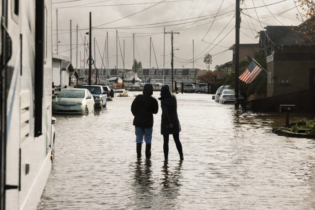
Thousands of people in San Rafael’s poorest community are at a growing risk of being islanded by flood waters, with no drivable escape route. Central exit roads are just three to four feet above sea level and already see some flooding during winter storms. Substantial storms, king tides and earthquakes, pose threats that are only worsening with sea level rise, which is happening at an increasing rate of 0.17 inches a year, according to data from NASA.
“In the past, the flood level was 10 feet, and that’s what we built to, and now, because of these emissions, sea level is going to continue rising through generations. It will be a dynamic that doesn’t stop. We’re kind of on a train now,” said Kate Hagemann, San Rafael’s Climate Adaptation and Resilience Planner.
She spoke recently in conjunction with an exhibit on sea level rise at the Marin Museum of Contemporary Art, one of numerous community conversations organized by advocates to publicize the impact of climate change on San Rafael, particularly the vulnerable Canal community.
The Canal is one of many shoreline neighborhoods in the Bay Area bearing the brunt of rising seas and increasingly intense storms. According to a recent study by the California Institute of Technology, the land in San Rafael and other shoreline Bay Area cities is subsiding at a steady rate of more than 0.4 inches per year. Combined with tide elevation estimates, local sea levels could permanently rise more than 17 inches by 2050.
The peninsula that defines the Canal district has subsided into the shape of a bowl since the land was created with infill in the 1960s, and its central exit roads dip to about three feet above sea level. Daily high tides range from four to six feet, according to tide charts. King tides can reach up to eight feet, according to data provided by Cory Bytof, sustainability program manager for the city of San Rafael.
Bytof said in an email that the two areas in the Canal that are the lowest and see flooding on occasion are at the intersection of Bellam and Kerner Boulevards, which are the main exit routes to Highway 101, and along Harbor Street between Francisco Boulevard East and Mill Street, which leads to the Grand Avenue bridge that is also less than four feet above sea level and likely to flood. During the winter rainy season, with a king tide, these spots become ankle-deep streams.
“I have experienced the flooding,” said Canal resident Glendy Barrios in an April interview at her home. “Last year, I was trying to get out of my parking lot with my car, and I couldn’t because the street was flooded, and the water had no place to go.”
An island of poverty in an ocean of wealth
According to the Marin County website, the Canal is the most densely populated FEMA flood zone in the county. The U.S. Census counts 10,000 residents in the Canal neighborhood, but city officials estimate the number may be 16,000 or more. Census data shows residents are 98% Hispanic; a quarter of them live below the poverty line and two thirds of the adults lack a high school diploma. They fix cars, build houses and change the diapers of other mothers’ babies in greater Marin County, one of the wealthiest regions in California.
Community advocates suggest that residents are fearful of a police presence, given the current political climate, and less inclined to report flooding problems to local authorities.
San Rafael’s director of public works April Miller said that during winter rain events, there are municipal crews throughout the city that check areas they know are likely to flood, and they have system alerts for power outages at flood pumps, but it would be hard to know what’s happening on every street. Residents usually call in when they see flooding.
Six inches of water will cause stalling in most vehicles, and one foot of water will cause a pickup truck to float, according to the National Weather Service. There are no plans for the city to construct an auto evacuation route to higher ground, and there is no publicly visible evacuation map.

The maps for the Canal district are on a password protected site.
“They are not public for a few reasons,” Quinn Gardner, San Rafael’s deputy director of Emergency Management, wrote in an email. “Namely, routes can change. Giving people something they may rely on but go against a particular situation holds risk. We are currently working on adding language to the PDF of the maps that clarifies this distinction. The maps won’t be public until that disclaimer is added.”
In an April interview at the San Rafael Public Safety Center, Gardner said the evacuation maps for the Canal are like those of other cities on the county website.
“What most of them say is get to a main road, get to 101, or get away from the hazard or the risk,” Gardner said.
That’s not so easy when floodwaters block access to Highway 101, which itself can be vulnerable to high tides. A 2024 sea level adaptation study by the Transportation Authority of Marin suggested elevating key roads and other transportation infrastructures, including Highway 101, Interstate 580 and SMART rail stations.
“However, this approach would not provide flood protection for the surrounding community,” the report said.
“If we really were looking at seeing two, three, four, five feet of water, the messaging would be a required evacuation,” said Gardner. “In which case, there would be door-to-door activity, there’d be high-low sirens, there would be a lot of different communication methods where people would basically be told to leave and if you choose to stay, we can’t guarantee your safety.”
At the museum conversation, San Rafael residents and homeowners decried the city’s lack of urgency.
“There are things that are critical to face right now that probably don’t cost a whole hell of a lot of money,” added Jeff Rhoads, an architect and urban planning consultant.
“One is coming up with an evacuation plan,” he said. “For a community like the Canal neighborhood, one of the big losses is having your car parked on the street and flooded. Now how do you get your child to school or how do you get to work? One of the things we can do as a city straight away is focus on getting together an evacuation plan and strategies so that we can get people and their automobiles out of harm’s way.”
Rhoades said the other immediate concern in the Canal is soft-story failure. According to a 2022 study by the U.S. Geological Survey, there is a severe hazard of liquefaction due to sea level rise in the Bay Area, especially in artificially filled areas where the water table is already shallow.
Most of the apartment houses were built in the 1960s and early 1970s with a level of parking underneath them, he said.
“These buildings are supported by a bunch of toothpicks, basically. In a seismic event, that whole building can just drop on the ground,” he said. “As a community, we can focus on spending about $10,000 per unit to strengthen those buildings. That strengthening occurs in the garage, so it doesn’t displace people. This is one of the things that is almost embarrassing that we’re not focusing on.”
Getting to high ground
Twenty-one feet above sea level is the safe height of the nearby Target and Home Depot shopping center, but getting there could be a challenge in a storm. The elevated man-made retail block looks like a mesa in the desert. It is separated from the Canal by a sunken wetland that spans a distance of about four soccer fields. It is possible to get there on foot using the Bay Trail, a gravel path on the ridge of a levee. The levee is eight feet above sea level and separates the waters of the Bay from the wetland.
“It’s a tool in the toolbox,” said Gardner about the levee footpath. “We would need to know if it is a wave situation, or there’s potential erosion to that levee, and that would be something we’d rely on our engineers to look at. But yeah, it’s why we tell people to know multiple ways out of your neighborhood. If we were truly in a life safety emergency where we had people trapped in flood water that was dangerous, not just a foot or two coming up to the ankle, we’d be at the point of calling the National Guard for large people-moving vehicles,” Gardner said.
That would create a situation where emergency responders are trying to get many high-profile vehicles into an area to evacuate hundreds of people, she said.
“In the grand scheme of a year, we might have one or two significant rain events that correlate with a really high tide,” said Gardner. “We’re not saying you can’t be home huge portions of the time. If there’s a couple days a year where just not being at home makes sense, people have to start culturally, mentally and financially planning for that.”