

By Megan Fan Munce, Staff Writer
Oct 29, 2026
Read article in full at SF Chronicle
There was no warning on the morning that Anabel found herself blocked by the water.
It was January, and as the San Rafael resident left for work, she found herself stuck behind a long line of cars.
Some began turning around, but Anabel waited, wondering what was happening as she searched for warnings on the radio, she recalled in Spanish.
When Anabel finally reached the front of the line, she saw high waters had cut off the entrance to Highway 101. She tried to take another route, only to learn the highway itself was flooded.
“I couldn’t turn around,” Anabel, who asked the Chronicle to withhold her last name, citing community unease about recent immigration enforcement activity, said in Spanish. “I was worried. If my car broke down, I would be in the middle of the water.”
It’s a scenario that seems very likely to repeat itself — potentially in a worse way — this winter for many residents of Marin County’s most populous city. A historically strong El Niño is poised to raise water levels higher than ever, especially on king-tide days such as the one Anabel experienced. It’s a particular concern for San Rafael’s Canal District, where nearly one-fifth of city residents are already living largely below sea level.
City officials are warning that muddied seawater could fill neighborhood streets and take hours or even days to recede. Since the only two evacuation routes are at risk of flooding, emergency responders would have to rescue stranded residents by boat.
In the worst case scenario, those who don’t get out in time might end up spending days stranded in their homes without power or even water, according to Quinn Gardner, the city’s emergency manager.
“As rudimentary as it can sound,” Gardner told city council earlier this month, “a five-gallon bucket and some trash bags could be the situation that you need to be able to shelter in place for a couple of days until the water is safe to leave.”
Bottom of the bowl
Marin, surrounded on three sides by the Pacific Ocean and the San Francisco Bay, is one of the most flood-prone counties in California. But San Rafael is unique in that it faces flooding risk both from high tides and from winter storm runoff, which trickles down from the hills into low-lying areas, according to Gardner.
The worst of it is located in the 2.2-square-mile Canal District on the city’s southeast side, where the San Rafael Creek runs from the bay to Highway 101.
Here, the land — filled in atop a marsh over a century ago — is sinking as the seas rise, forming a bowl. The Canal District is the bottom of that bowl. Many of the neighborhood’s major thoroughfares sit below sea level; even on sunny days, the high tides can flood these streets and send water into vehicles and first-floor apartments.
Should even a fraction of the Canal District’s more than 12,000 residents need to be evacuated, there won’t be enough space in the county to house them, Gardner said. Earlier this month, the city declared a local state of emergency. It set aside $500,000 in city funds and secured $3 million from the county for flood preparedness and response.
These funds will go toward more water pumps and community outreach, but it may not be enough.
“We are using money to try to reduce the volume of water that will impact the community, but this is a billion dollar problem for San Rafael in the grand scheme of things, and we’re not going to solve it in two to three months,” Gardner said.
The population of the Canal District stands apart from Marin County, and even San Rafael. Here, more than 80% of residents are Latino compared to just 20% of the county overall, according to the most recent U.S. Census data. The Canal Alliance, a nonprofit offering legal services and support to the community, estimates about half of residents are low-income and must spend 50% of their income or more on housing.
It’s also one of the most densely populated parts of the Bay Area. Apartment complexes, auto shops and grocery stores are packed so close to the canal’s edge that residents in homes just a block away may not be able to see the water.
That’s part of the problem, said Gardner: Even when the National Weather Service puts out warnings about coastal flooding during high tides and storms, many living in the community may not realize it applies even to the canal.
Nowhere to go
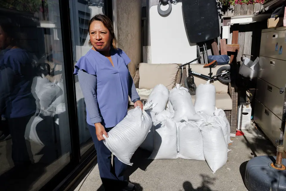
Last year, during another high tide, the water stranded Anabel in Corte Madera for three hours while she was trying to drive her children south to sports practice in Mill Valley. Back home in the Canal District, street flooding has come up past her ankles. At some points, the water has been high enough to seep through her car door. It would’ve gotten into her house, too, she said, if not for sandbags piled up against her front door.
During strong storms, runoff water can also carry mud and debris down from the hills into homes close to the freeway. Last year, a mudslide nearly topped the fence outside the San Rafael apartment where Marina, a longtime Canal District resident, now lives just outside the neighborhood. (Marina also asked to withhold her last name due to community concerns about immigration enforcement.) With this year’s El Niño, Marina worries a new mudslide could overcome the fence entirely and carry dirt and debris directly into her home.
Marina is heeding the city’s warnings. She’s stocked up on inhalers for two of her children who have asthma and is trying to make sure her car always has gas in it in case they need to evacuate. Marina is also trying to buy every member of her family a pair of rainboots. But these things all have a cost that are getting harder to bear, she said.
“The rents are so high, plus the bills and they have you also paying for more utilities now,” Marina said. “Trying to put money aside to be prepared, which we know is necessary, that’s gonna be so hard.”
Marina’s greatest fear is getting trapped.
To prevent this from happening, the city is encouraging residents in low-lying areas like the Canal District to evacuate as a precaution ahead of especially high tides, expected to hit right before and during Thanksgiving and Christmas. They’ve suggested those living in first-floor apartments to consider temporarily moving in with neighbors on higher floors.
This solution feels unrealistic to Marina. Housing is already crowded; the Canal Alliance estimates the community, one of the most affordable in Marin, has virtually no rental vacancies. . Many residents’ entire families live in the Canal District; there is nowhere for them to evacuate to.
The city has capacity to house about 3,000 people in Red Cross shelters, but many of those shelters themselves lie in floodplains, according to Gardner. They’d likely have to turn to other counties for help — potentially forcing evacuees to move dozens of miles away from their jobs, homes and community.
“When it floods, like it happened last year, people didn’t even know where to go,” Marina said. “This year is gonna be worse.”
A worrying forecast
There are still major uncertainties in how this winter will play out. Though El Niño is generally associated with greater rainfall, how and when that rainfall occurs has an impact on the city’s ability to respond, according to Gardner. If an inch or so falls every day for a month, the city’s stormwater draining system may be able to keep up, she said. But if a torrential downpour hits just as the tides reach their peak, local infrastructure could easily be overwhelmed.
Marina hopes the city’s advanced warnings may prompt people living in wealthier and higher elevation parts of Marin County to donate supplies to local nonprofits or offer up spare parking spots and vacation homes to evacuees.
Fear and distrust of the government, especially as immigration enforcement activities have increased under President Donald Trump, make many residents hesitant to apply for government-provided resources even when they’re available, said Carly Finkle, senior policy manager for the Canal Alliance.
If the city evacuates the Canal District, Anabel and her family plan to head north to Santa Rosa, she said, but getting a hotel room for a family of five would be expensive, especially if demand from other evacuees drove up the rates, she said.
If their home were permanently damaged, she’d need to find a way to put together enough money to put down a deposit and pay for rent on a new apartment. It’d probably be smaller and more expensive, and most of all, it wouldn’t be home.
Initially, Anabel moved to the Canal District because she had family living there, she said. Now, more than 25 years later, it’s become home. She feels comfortable here, she said — the businesses are Latino, the doctor’s office is nearby and she can walk around instead of having to drive or take the bus.
She worries not just for this winter, but for the long-term future of the neighborhood as climate change melts glaciers and heats the oceans, gradually raising the seas even higher.
“If the Canal District sinks, it will be a great loss,” Anabel said in Spanish.